JodyT

Posts : 394
Join date : 2010-03-15
 | Subject: North Cumberland WMA - May 1st Ride Report  Sun May 02, 2010 5:45 pm Sun May 02, 2010 5:45 pm | |
| Below is the Ride Report Filed By Mr Dan.... - Dan wrote:
- We left Turley about 9 EDT heading up the mountain on a warm up trail, then Rock Spring Gap over to the haul road at Jenny Gap, down the haul road and stopping for a few minutes chatting with some campers at the Eternal Flame. From there, we headed toward New River, crossed the Swinging Bridge (now concrete) and up Lloyd Mtn and trail 22. 22 has some fairly nasty up/down hils to negotiate, and some of the best scenic vistas anywhere. The vistas were good, but not great, due to the heavy low hanging overcast. We hung a right on 21, then a left on 57.
That's when troubles began... several large trees were down. We were able to easily bypass the first, no way on the second. Thanks to Rooster and his chain saw and a few minutes later, the trail was clear after Rooster had cut a nice 10' log. Since it was mostly downhill, we were able roll the log off the trail. A mile or so on down, some fanatic had sawn several pines across the trail... probably a hunter. Rooster and the team soon dispatched that blockage. Rain is now starting to fall pretty good and everyone took on the rain gear.
Well, it's now getting close to lunch time, and the rain is falling. Where could we get out of the rain to eat? Somewhere out of the depths of my memory I seemed to remember a shelter being at Bull Creek Church, about three miles down the creek. We hit the gravel, trail 47, and were soon there. Sure enough, there was a nice shelter building, complete with tables and chairs, even some picnic tables. An outdoor restroom was even nearby for the ladies.
We took our leasurely time eating, watching it rain, and as usual, the tales were flying bountifully. After a bit, everyone's lunch business was taken care of. The preplanned route was rained out, but now the rain was subsiding; so we headed off for more adventure.
We headed west on 47, cut across to 9, then south on 1. It's about quit raining and trail 14 is getting close. Climb the mountain on 14, or go farther. Let the excitement begin... The hill climb on 14 is a challenge to say the least. When Jody saw that hill, he jammed on the brake, shoved his RZR into Low, got a wild look in his eye, cleaned his windshield, then with both hands on the wheel... gave it a gallon. What a ride!!! Hold on with both hands and pray the seat belts hold. We stopped at the first easy spot and Jody went back to help the others. I think he got some good photos/videos of the difficulty of that hill. Tales are gonna be flying about this one... and several will be remembered for many moons to come. I think everyone should tell his own. One of the best is that JodyT and I are now, "Officially... crazy!"
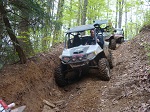
Then on along 14, with several glimpses of good vistas. On to Bowling Gap, where we would cross back onto Royal Blue, via the remainder of 14, the high leg of 28 and and north on 21. From there we headed towards Lowe Gap, going down Bowling Gap trail where someone wiped out about half onf a good trail with a dozer. We then crossed Smoky Creek Rd, taking Lowe Cemetary Rd up the creek to a sewer washout. The RZRs went across, almost, with the ATVs going around a bypass. Buck was the last to cross, the photo above tells the story of his adventure there. A little tow and we are off up the mountain toward Lowe Gap and Bootjack Mtn.
We circled Bootjack, I figure the over all best trail on Royal Blue. After completing that circle, it's back to Lowe Gap and down Old Smokey Rd to Shea. This trail is tight, crooked, and loads of fun. From Shea, we up AshLog Mtn to the ruins, then Graves Gap Rd to Pind Bald, then Cross Mtn Rd to Turley Rd and down to the the parking lot.
I think everyone was ready to get back. We were tired, damp, maybe even wet in places, but spirits were soaring high.
Amazingly, no flats or other mechanical problems. What a day...
When can we do it again? | |
|
mason

Posts : 1022
Join date : 2010-03-11
Age : 69
Location : austinville,va.
| | Subject: Re: North Cumberland WMA - May 1st Ride Report Sun May 02, 2010 5:59 pm | |
| sounds like ya had fun and good report  | |
|
ChrisC
Admin
Posts : 6746
Join date : 2010-03-10
Age : 57
Location : Marietta GA
| | Subject: Re: North Cumberland WMA - May 1st Ride Report Sun May 02, 2010 6:01 pm | |
| Good report Jody....  | |
|
Stealth

Posts : 466
Join date : 2010-03-10
Age : 52
Location : Wise Va,
| | Subject: Re: North Cumberland WMA - May 1st Ride Report Sun May 02, 2010 7:35 pm | |
| | |
|
Sponsored content
| | Subject: Re: North Cumberland WMA - May 1st Ride Report | |
| |
|